

Downtown Indianapolis Photo Walk: From Mass Ave to White River State Park
This walk links nine photo stops in downtown Indianapolis, from the diagonal Massachusetts Avenue through the memorials of the city center to the museums and the river in White River State Park. Every stop is reached on foot; the map below shows the order, and each section says what to look for and which light suits it.
9 stops · about 2.7 mi between the stops in a straight line
The route
- Mass Ave – 0.5 mi to the next stop
- Indiana World War Memorial Plaza – 0.4 mi to the next stop
- Monument Circle – 0.2 mi to the next stop
- Indiana Statehouse – 0.6 mi to the next stop
- Lucas Oil Stadium – 0.6 mi to the next stop
- Eiteljorg Museum – 0.1 mi to the next stop
- Canal Walk and Indiana State Museum – 0.1 mi to the next stop
- NCAA Hall of Champions – 0.2 mi to the next stop
- White River State Park
Planning the light
Start in the afternoon and reach White River State Park for golden hour and sunset. In late June golden hour begins at 8:36 p.m. and the sun sets at 9:16 p.m. in the west-northwest (302°); at the spring and fall equinox it sets around 7:57 p.m. and 7:42 p.m. due west (271°); at the winter solstice golden hour already begins at 4:40 p.m., with sunset at 5:23 p.m. in the west-southwest (240°).
For blue hour, walk back to the Indiana World War Memorial: its blue lights between the columns are what make it stand out after dark. Blue hour ends at 9:49 p.m. in late June, 8:24 p.m. at the spring equinox and 5:54 p.m. in December.
1 Mass Ave
Massachusetts Avenue is one of the four diagonal streets in Alexander Ralston's 1821 plan of Indianapolis. The Mass Ave Cultural Arts District follows it for 0.86 miles, from New York and Delaware streets at its southern end to Bellefontaine Street. Part of it is the Massachusetts Avenue Commercial District, listed on the National Register of Historic Places since 1982. Because the avenue cuts across the street grid at an angle, its building fronts form long diagonal lines – a strong lead-in for street photos.
2 Indiana World War Memorial Plaza
The plaza was conceived in 1919 to honor the veterans of World War I and to house the national headquarters of the American Legion. It covers five blocks between Meridian, St. Clair, Pennsylvania and New York streets. Its centerpiece, the Indiana World War Memorial, is modeled on the Mausoleum of Halicarnassus and rises 210 feet; inside, the Shrine Room is 110 feet high. North of it, a 100-foot black granite obelisk from 1923 stands in a two-level fountain of pink Georgia marble with multicolored lights, and the black granite cenotaph on American Legion Mall is framed by four shafts topped with gold eagles. In University Park at the south end stands the Depew Memorial Fountain, completed in 1919, with statues of Abraham Lincoln and Benjamin Harrison. The plaza became a National Historic Landmark District in 1994.
3 Monument Circle
The Soldiers' and Sailors' Monument stands at the center of Monument Circle, the brick-paved circle at the heart of Ralston's 1821 plan. Designed by Bruno Schmitz, built between 1888 and 1901 of oolitic limestone from Owen County and dedicated on May 15, 1902, it is 284 feet 6 inches tall. The 30-foot statue of Victory on top faces south, so the south side is the one to photograph her from; Rudolf Schwarz's limestone groups War and Peace stand at the base, surrounded by pools and fountains. An observation deck is reached by stairs or elevator. The photo above was taken looking southeast across the circle from the Sheraton Indianapolis City Centre. On the circle itself, the Hilbert Circle Theatre opened in 1916 as a movie palace and is now home to the Indianapolis Symphony Orchestra; it is listed on the National Register of Historic Places.
4 Indiana Statehouse
The Indiana Statehouse at 200 West Washington Street was built in 1888 to designs by Edwin May in the neoclassical style. It is the fourth building to house Indiana's state government and holds the General Assembly, the governor's office and the Indiana Supreme Court. It is listed on the National Register of Historic Places.
5 Lucas Oil Stadium
A short detour south leads to Lucas Oil Stadium on the south side of South Street. Opened on August 16, 2008 and designed by HKS, the stadium has a retractable roof and seats 62,421. It replaced the RCA Dome as the home field of the Indianapolis Colts, which made room for the expansion of the Indiana Convention Center. The photo shows the field seen from the stands.
6 Eiteljorg Museum
The Eiteljorg Museum of American Indians and Western Art opened in 1989 in White River State Park. It shows art by Indigenous peoples of the Americas and the Western American paintings and sculptures collected by businessman Harrison Eiteljorg (1903–1997), and its collection of contemporary Native art is among the finest in the world. Inside, photograph only where the museum allows it; the building itself is the subject from the outside.
7 Canal Walk and Indiana State Museum
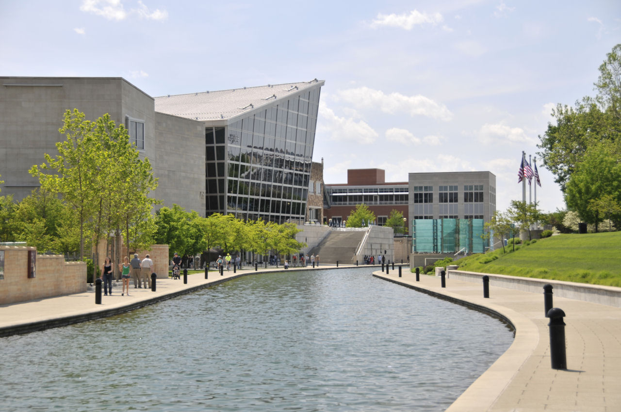
The Central Canal was dug between 1836 and 1839 as part of a canal meant to link the Wabash and Erie Canal with the Ohio River; after the Panic of 1837 only eight miles were finished, all in Indianapolis. South of Interstate 65 the 3.4-mile Indianapolis Canal Walk follows it as a linear park, with paths on both banks and pedestrian bridges between them – the bridges and the water give reflections and lines that lead into the picture. At the end of the walk stands the Indiana State Museum, founded in 1869, with exhibits on Indiana's science, art, culture and history; the photo shows it on the left, with the Military Park entrance on the right.
8 NCAA Hall of Champions
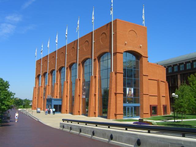
The NCAA Hall of Champions is an interactive museum in White River State Park and part of a three-building complex with a conference center and the headquarters of the NCAA and the National Federation of State High School Associations. It was built when the NCAA moved its headquarters from Kansas City, Missouri, to Indianapolis, and the complex was designed by the Indianapolis-born postmodern architect Michael Graves.
9 White River State Park
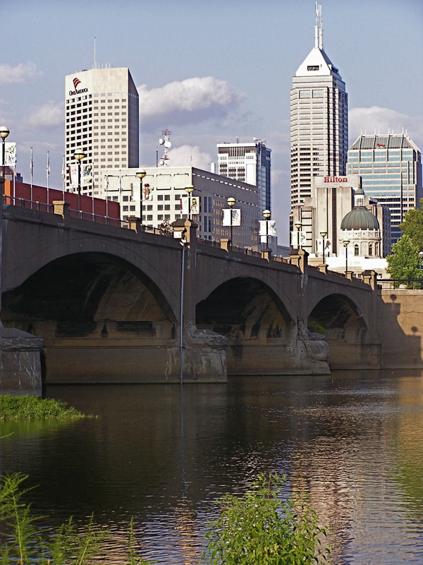
The walk ends on the White River. White River State Park covers 267 acres on both banks and holds the museums of the previous stops as well as the Indianapolis Zoo, Victory Field and the Everwise Amphitheater. The Old Washington Street Bridge has been a pedestrian bridge since 1994 and links the park's green spaces with White River Gardens, a 3.3-acre botanical garden opened in 1999 that held nearly 50,000 plants of more than 3,000 species in 2021. Near the bridge, a memorial honors four men who had helped build the park and died in a plane collision in 1992. This is the place for sunset – the times are under “Planning the light” above.
Further photo spots in and around the city – from the Children's Museum to the Indianapolis Motor Speedway – are on the Indianapolis photo guide.
More photo tours nearby
- North Indianapolis Photo Tour: Museums, the Canal and Broad Ripple
5 stops – Photo tour north of downtown Indianapolis: Benjamin Harrison's home, the Children's Museum, the State Fairgrounds, Broad Ripple and Newfields. - West Indianapolis Photo Tour: Zoo, Speedway and Eagle Creek Park
4 stops – Photo tour west of downtown Indianapolis: the Indianapolis Zoo, historic Speedway, the Motor Speedway and its museum, and sunset at Eagle Creek Park. - Day Trip Northeast of Indianapolis: Conner Prairie, Pendleton, New Castle and Mounds State Park
4 stops – Photo day trip northeast of Indianapolis: Conner Prairie in Fishers, historic Pendleton, the Basketball Hall of Fame and sunset at Mounds State Park.